

Early medieval England in long-term perspective: the English Landscapes and Identities project
We live in the digital era, and archaeologists are increasingly engaging with 'big' data. A recent project at Oxford sought new answers about the landscapes of early medieval England from the longue durée.
What does the early medieval past look like from the perspective of the later prehistoric and Roman periods, and through the lens of ‘big’ data? This was one of the many questions addressed by the ERC-funded English Landscapes and Identities (EngLaId) project (School of Archaeology, University of Oxford). EngLaId investigated the period c. 1500 BC – 1086 AD, from the middle Bronze Age, when field systems were first laid out on a significant scale across the English landscape, to the Domesday survey, the first substantial documentary survey of landholdings in what is now England. Here, I briefly comment on this project from a medievalist’s perspective.
The EngLald project
EngLaId set out to ‘map’ change and continuity across period divisions in the territory that is now England. The team consisted of Chris Gosden (PI), Anwen Cooper (prehistoric researcher), Zena Kamash / Tyler Franconi (Roman researcher), myself (early medieval researcher), Victoria Donnelly (DPhil student, grey literature), Sarah Mallet (DPhil student, stable isotopes), Dan Stansbie (DPhil student, food production and consumption), Miranda Creswell (project artist), and Laura Morley (research coordination). Although each researcher was in theory responsible for a specific theme or time period, in practice we all worked across period and disciplinary boundaries.
EngLaId ran from 2011–2016, approximately 25 years after the introduction of Planning Policy Guidance 16 (PPG16) in the UK, which had an enormous impact on British archaeology. Put simply, PPG16 made archaeological investigation a routine element of the planning process. From 1990 onwards, whenever construction or other infrastructure developments took place, archaeologists had to be involved. The result was a massive explosion in archaeological investigations across all periods (Fig. 2). Similar legislation was subsequently imposed across all EU member states following the 1992 Valetta Convention. Archaeology had entered the age of ‘big’ data (at least for archaeological standards) and the question was, how do we deal with this?
Characterising landscapes
One question that kept coming up was, does more data necessarily lead to better understanding? Attempts to characterise and divide the English landscape based on shared characteristics such as settlement types date back to at least the earlier 20th century with Cyril Fox’s 1932 work The Personality of Britain, which divided the country into an upland zone in the north and west, and a lowland zone in the south and east. Since then, numerous other attempts have been made using different methodologies and datasets, resulting in different ‘zones’, ‘regions’ or ‘pays’ dividing up the English landscape (Fig. 3). The question was, do these ‘regions’ stand up to scrutiny?
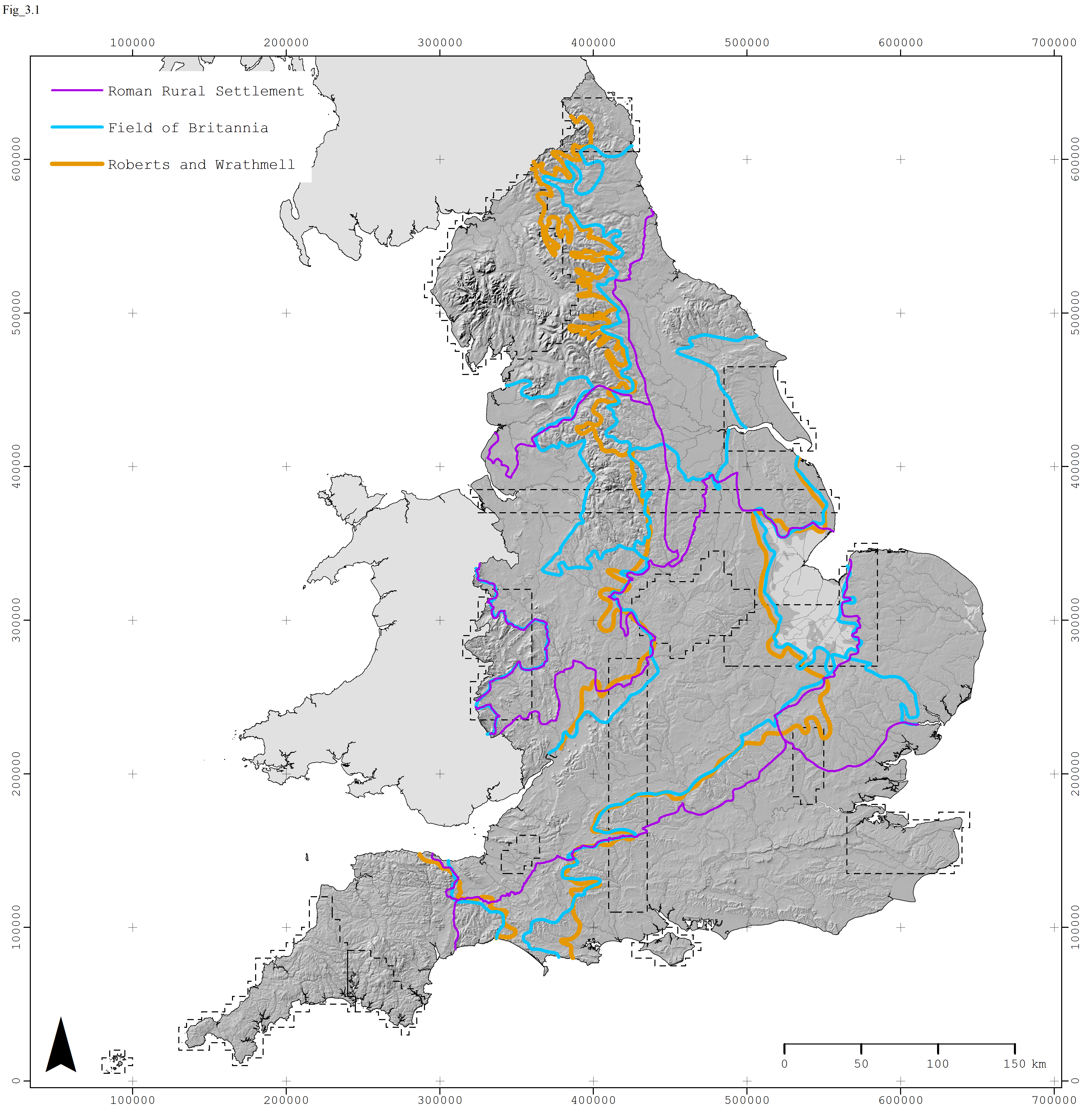
Fig 3: Regions in the English landscape, based on Robert and Wrathmell’s Atlas of Rural Settlement in England (focusing on the medieval period) , the Roman Rural Settlement project (focusing on the Roman period), and the Fields of Britannia project (focusing on the Roman to early medieval transition).
Taking a bottom-up approach, the EngLaId project amalgamated over 900,000 pre-existing digital records from roughly 100 digital repositories into one database (almost immediately out of date as more archaeological data just keeps coming and coming), and then spent several years analysing, mapping, interpreting and thinking about what it all meant. We looked at the data on a nationwide scale but also on a regional and local scale through case study and test areas of different sizes.
To return to the question whether more data necessarily leads to better understanding, the answer is both no and yes. No, because we realised that many of the regions identified by other scholars, including Fox’s upland and lowland zones, still hold true to a greater or lesser extent. Yes, because it became clear that any approach that tries to draw lines runs the risk of grossly oversimplifying the past. People’s relationships with their pasts was complex, changeable and often different depending on the type of evidence or the specific time period or even generation.
Still, some large patterns emerged. One example is our graph of plough-soil finds across time, which shows a huge peak in the Roman period (Fig. 4). This is something that every English archaeologist knows, but (to our knowledge) no one had ever charted it. As a medievalist, looking at a graph like this two questions spring to mind: first, how and why did people’s engagement with portable material culture change so drastically over such a short period of time? Second, what happened to all that Roman ‘stuff’ (and what does this imply for our understanding of the 5th century AD)? Future research that is unrestrained by traditional period divisions will hopefully take this further.
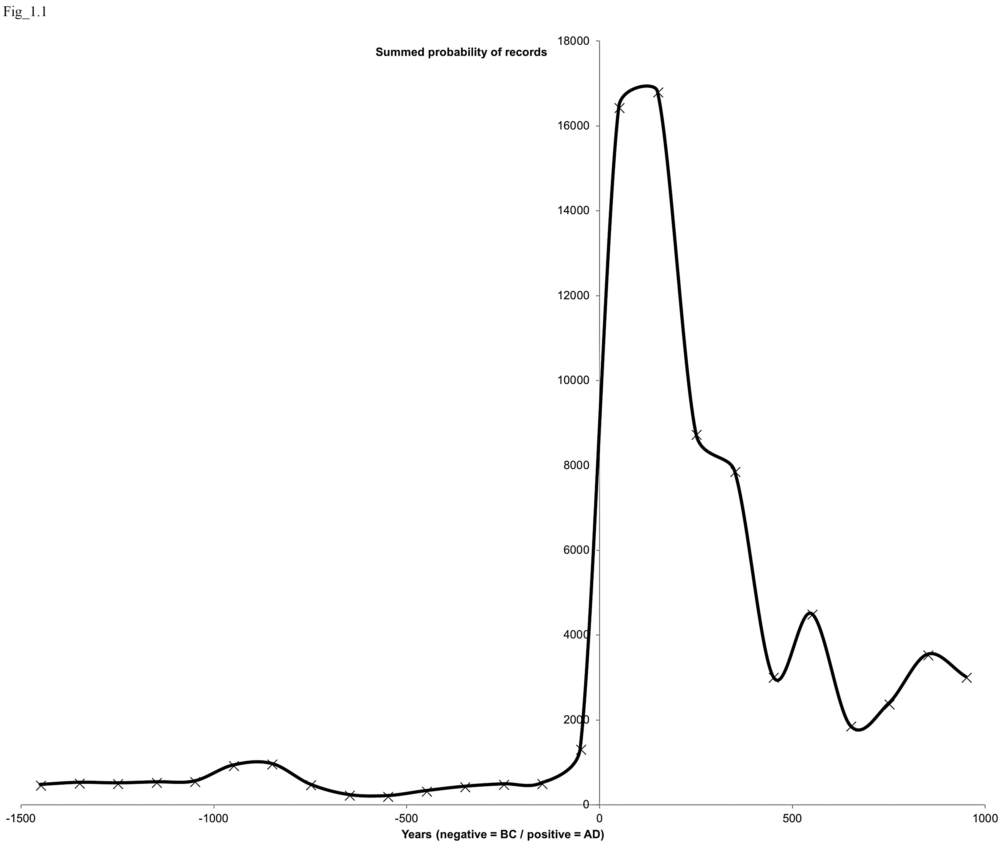
Fig 4: summed percentage probability of plough-soil finds falling within century time slices, represented by records from the Portable Antiquities Scheme (PAS). Note that this graph excludes coins, and that – given the high quantities of Roman coin finds made by metal-detectorists – the peak would be much higher still if these had been included. Figure by Chris Green.
Boundaries and enclosures
The early medieval period posed a specific methodological challenge. There is a wealth of documentary and place-name data that medieval archaeologists routinely incorporate in their work, which is absent for the prehistoric and – almost to the same extent – Roman periods in Britain. Few medieval archaeologists nowadays would argue in favour of the rejection of historical source material, as was suggested during the brief heyday of the ‘New Medieval Archaeology’ in the early 1980s. How, then, does one compare a period for which there are masses of non-archaeological yet still-relevant data, to periods for which there are none?
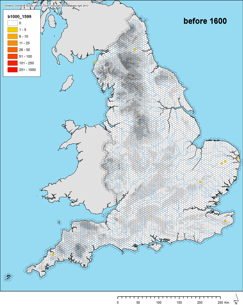
It was entirely beyond the scope of the EngLaId project to do the wealth of scholarship on the place names and documentary sources of early medieval England justice. Our ‘big’ data perspective dictated that we thought in terms of broad-brush patterns and trends, so one of the questions we asked instead was, how did society change when writing became an integrated part of how people did things? One archaeological pattern that had struck us during our mapping exercise was that the density of physical boundaries – enclosures, enclosed field systems and linear boundaries, often seen as territorial divisions, expressions of power, or at least a division of space into ‘us’ and ‘them’ – reached an all-time low in the early medieval period (Fig. 5).
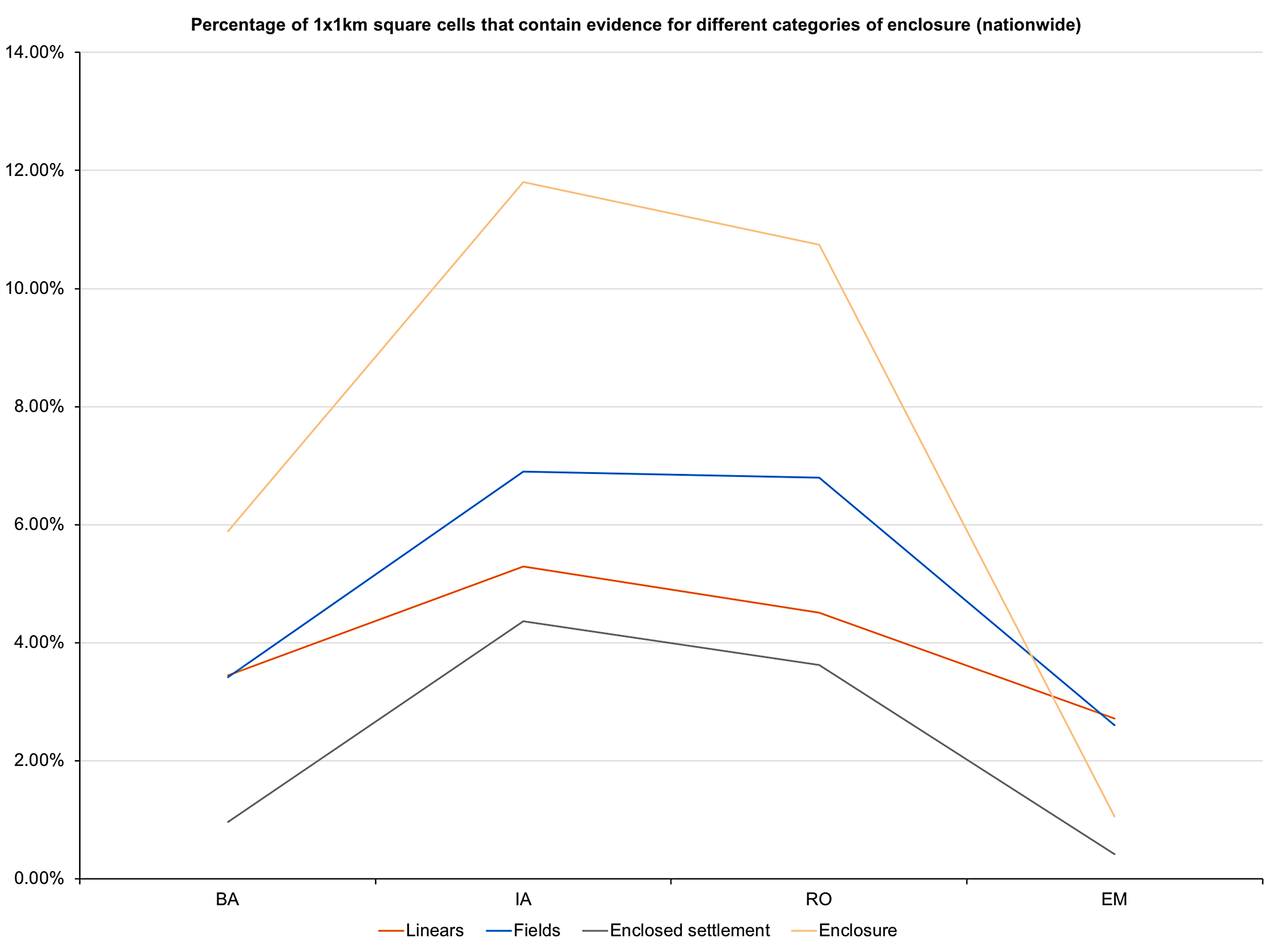
Fig 5: The presence of physical boundaries in the landscape (presence/absence in 1 x 1 km squares), mapped over time.
In part, this was probably a result of the fact that the landscape had become gradually more enclosed, and that older enclosures remained in use or were periodically re-used: more fieldwork is needed to identify the extended chronologies of earthworks. There is also the issue of how we record things: a common distinction in prehistoric and Roman scholarship between ‘enclosed’ and ‘unenclosed’ settlement, for example, is not used for early medieval settlements in large parts of England. At the same time, this reflects a real difference with preceding periods. Medieval villages and hamlets may have had internal divisions but were, on the whole, not ‘enclosed’ settlements (towns, on the other hand, were). Medieval open fields were different, in terms of their physical attributes and underlying socio-economic organisation, from prehistoric or Roman enclosed fields.
Returning to the issue of writing, the early medieval period also witnessed a large-scale increase of the use of documents for land management purposes, from charters detailing issues of land ownership to the Domesday Book itself. This had a far-reaching impact on the way in which landscape was divided and conceptualised, allowing for the existence of ‘invisible’ boundaries that, through the power of the word, were (in theory at least) as immutable as earthen banks (Fig. 6). Is it possible to see a connection? Again, more research is needed.
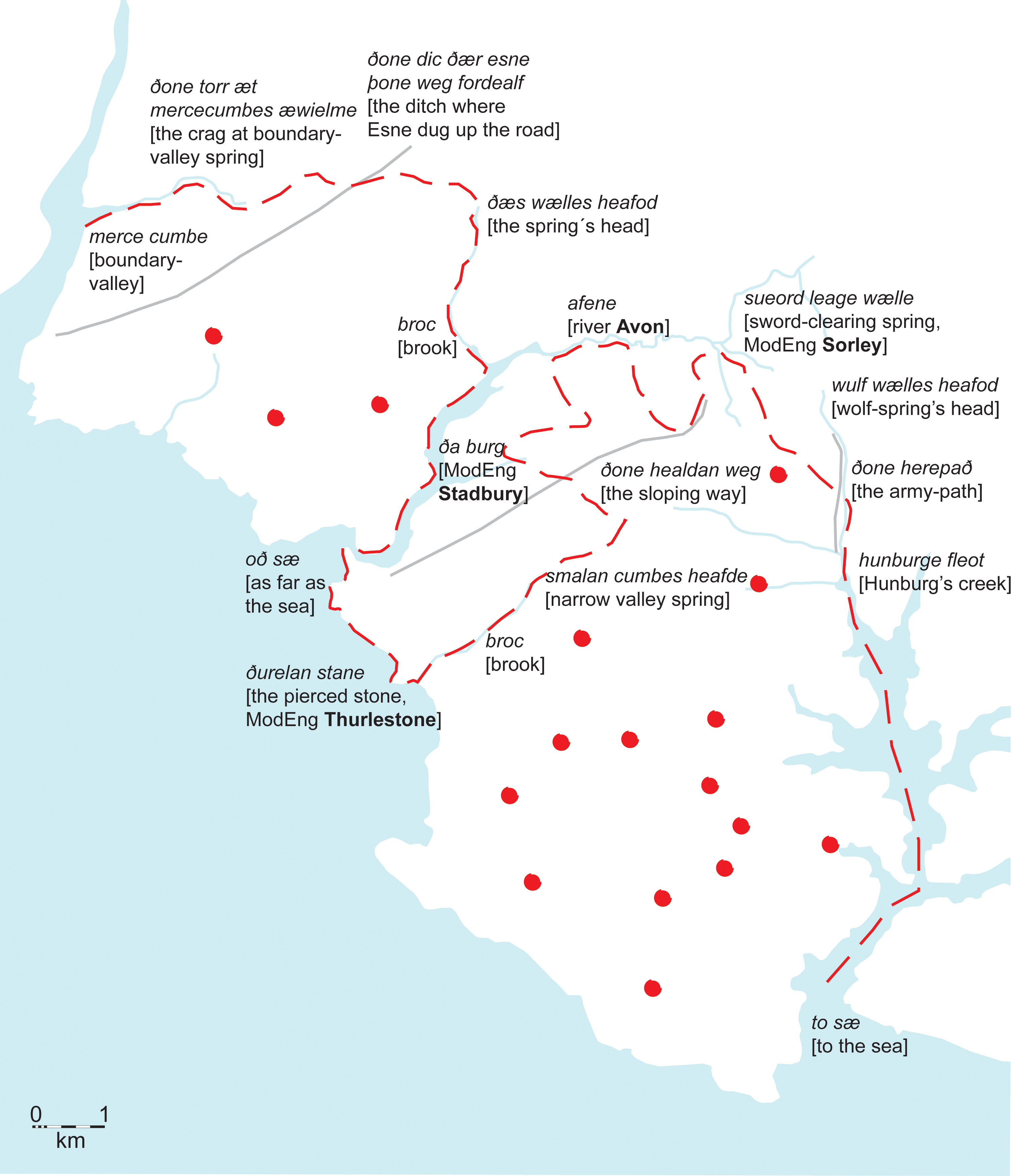
Fig 6: example of a charter boundary clause mapped on the ground, in this case the estate of South Hams in Devon. Based on L298.0.00/Sawyer 298; South Hams, Devon; AD 846. After Hooke 1994: 105–112.
The project’s main conclusions were published in a monograph and a visual atlas in 2021 but – as the monograph states – this is only a small selection of what is possible with such a rich resource (Fig. 7). We – the EngLaId team – hope that these publications are a starting point, even though our work is done.
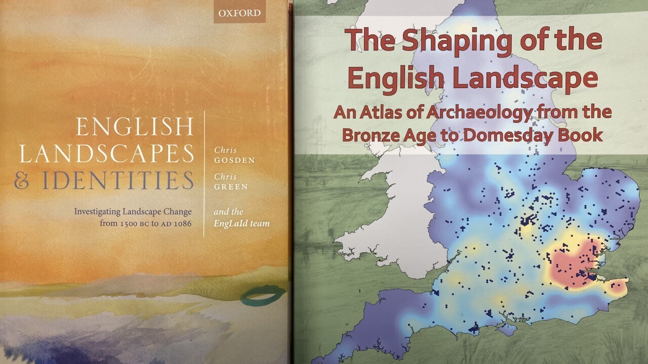
Fig 7: main EngLaId publications.
Further reading
Cooper, A., Creswell, M., Donnelly, V., Franconi, T., Gosden, C., Green, C., Kamash, Z., Mallet, S., Morley, L., Stansbie, D. and Ten Harkel, L. 2021. English Landscapes and Identities: investigating landscape change from 1500 BC to AD 1086, Oxford: Oxford University Press.
Donnelly, V., Green, C. and Ten Harkel, L. 2014. ‘English landscapes and identities. The early medieval landscape: methods and approaches’, Medieval Settlement Research 29: 43–55.
Gosden, C. and Ten Harkel, L. 2011. ‘English landscapes and identities. The early medieval landscape: a perspective from the past’, Medieval Settlement Research 26: 1–10.
Green, C. and Creswell, M., with contributions by A. Cooper, V. Donnelly, T. Franconi, R. Glyde, J. Kinory, S. Mallet, D. Stansbie, J. Talbot and L. Ten Harkel. 2021. The Shaping of the English Landscape: an atlas of archaeology from the Bronze Age to Domesday Book (School of Archaeology Monographs/Archaeopress).
Ten Harkel, L., Franconi, T. and Gosden, C. 2017. ‘Fields, ritual and religion: holistic approaches to the rural landscape in long-term perspective (c. 1500 BC-AD 1086)’, Oxford Journal of Archaeology 36.4: 413–37.
© Letty ten Harkel and Leiden Medievalists Blog, 2022. Unauthorised use and/or duplication of this material without express and written permission from this site’s author and/or owner is strictly prohibited. Excerpts and links may be used, provided that full and clear credit is given to Letty ten Harkel and Leiden Medievalists Blog with appropriate and specific direction to the original content.